
Datoteka:1700 CE world map.PNG

Veličina ovog prikaza: 800 × 397 piksela. Ostale rezolucije: 320 × 159 piksela | 640 × 318 piksela | 1.024 × 508 piksela | 1.280 × 635 piksela | 2.560 × 1.271 piksela | 4.500 × 2.234 piksela.
Izvorna datoteka (4.500 × 2.234 piksela, veličina datoteke: 364 KB, MIME tip: image/png)
| Ova datoteka je s Wikimedia Commonsa. Opis s njene stranice opisa datoteke prikazan je ispod. Commons je skladište slobodnih medija i datoteka za sve projekte fondacije Wikimedia. Možete i Vi pomoći. |
Sažetak
| Opis |
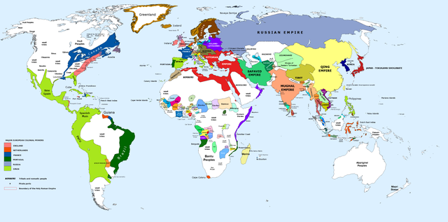
English: 1700 AD: An illustrative map of the world in the early colonial period. The Mughal Empire in India is at its greatest territorial extent. |
||
| Datum | |||
| Izvor | Own work. Blank map from File:World_Map_Blank.svg. | ||
| Autor | Urnanabha | ||
| Ostale verzije |
|

| Maps of world history | |
| BC | |
|
| |
| AD |
1 · 50 · 100 · 200 · 250 · 300 · 400 · 500 · 700 · 750 · 820 · 900 · 1200 · 1500 · 1556 · 1648 · 1700 · 1750 · 1815 · 1859 · 1871 · 1914 · 1935 · 1954 · 1989 · 2000 · |
|
Maps of colonization history | |
|
see also: Eastern Hemisphere only maps template (1300BC-1500AD) | |
| (this template: · view · discuss ) | |
.jpg)
._LOC_2001620596.jpg)
Licenciranje
Ja, vlasnik autorskog prava ovog djela, ovdje ga objavljujem pod sljedećom licencom:
Ova datoteka je licencirana pod Creative Commons Attribution-Share Alike 3.0 neportiranom licencom.
- Slobodni ste:
- da dijelite – da kopirate, distributirate i prenosite djelo
- da remiksate – da prilagodite djelo
- Pod sljedećim uslovima:
- pripisivanje – Morate pripisati odgovarajuće autorske zasluge, osigurati link ka licenci i naznačiti jesu li napravljene izmjene. To možete uraditi na bilo koji razumni način, ali ne tako da se sugerira da davalac licence odobrava Vas ili Vašu upotrebu njegovog djela.
- dijeli pod istim uslovima – Ako mijenjate, transformišete ili nadograđujete ovaj materijal, morate ga objaviti i distribuirati samo pod istom ili sličnom licencom poput ove.
Historija datoteke
Kliknite na datum/vrijeme da vidite verziju datoteke iz tog vremena.
| Datum/vrijeme | Smanjeni pregled | Dimenzije | Korisnik | Komentar | |
|---|---|---|---|---|---|
| trenutno | 12:00, 29 mart 2023 | | 4.500 × 2.234 (364 KB) | Yourlocallordandsavior | Slightly adjusted Mainland SE Asia borders. |
| 03:49, 28 februar 2019 |  | 4.500 × 2.234 (380 KB) | KnightxxArrow | Fixed inaccurate Cambodian border. | |
| 00:37, 5 april 2017 |  | 4.500 × 2.234 (401 KB) | Chamboz | Fixed wildly inaccurate Ottoman southern border. | |
| 02:10, 26 januar 2014 |  | 4.500 × 2.234 (328 KB) | Ukabia | Added states | |
| 23:31, 24 januar 2014 |  | 4.500 × 2.234 (38,36 MB) | Ukabia | Added African states | |
| 07:36, 13 januar 2013 |  | 4.500 × 2.234 (325 KB) | Urnanabha | User created page with UploadWizard |
Upotreba datoteke
Sljedeća stranica koristi ovu datoteku:
Globalna upotreba datoteke
Sljedeći wikiji koriste ovu datoteku:
- Upotreba na azb.wikipedia.org
- Upotreba na ce.wikipedia.org
- Upotreba na de.wikipedia.org
- Upotreba na en.wikipedia.org
- Upotreba na eo.wikipedia.org
- Upotreba na es.wikipedia.org
- Upotreba na et.wikipedia.org
- Upotreba na eu.wikipedia.org
- Upotreba na fi.wikipedia.org
- Upotreba na fr.wikipedia.org
- Upotreba na gl.wikipedia.org
- Upotreba na he.wikipedia.org
- Upotreba na hy.wikipedia.org
- Upotreba na id.wikipedia.org
- Upotreba na io.wikipedia.org
- Upotreba na it.wikipedia.org
- Upotreba na it.wikiquote.org
- Upotreba na ja.wikipedia.org
- Upotreba na lv.wikipedia.org
- Upotreba na my.wikipedia.org
- Upotreba na pap.wikipedia.org
- Upotreba na pnb.wikipedia.org
- Upotreba na ro.wikipedia.org
- Upotreba na ru.wikipedia.org
- Upotreba na shn.wikipedia.org
- Upotreba na te.wikipedia.org
- Upotreba na ur.wikipedia.org
- Upotreba na vi.wikipedia.org