
Datoteka:Arabian Peninsula dust SeaWiFS.jpg

Veličina ovog prikaza: 657 × 600 piksela. Ostale rezolucije: 263 × 240 piksela | 526 × 480 piksela | 841 × 768 piksela | 1.122 × 1.024 piksela | 2.504 × 2.286 piksela.
Izvorna datoteka (2.504 × 2.286 piksela, veličina datoteke: 853 KB, MIME tip: image/jpeg)
| Ova datoteka je s Wikimedia Commonsa. Opis s njene stranice opisa datoteke prikazan je ispod. Commons je skladište slobodnih medija i datoteka za sve projekte fondacije Wikimedia. Možete i Vi pomoći. |
| Opis |
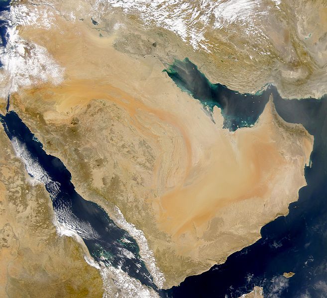
English: SeaWiFS collected this view of Arabia and of dust blowing across the Persian Gulf.
Español: La Península Arábiga vista desde el espacio |
| Datum | Taken on 2 mart 2000 |
| Izvor | http://visibleearth.nasa.gov/view_rec.php?id=898 |
| Autor | SeaWiFS Project, NASA/Goddard Space Flight Center, and ORBIMAGE |
| Ostale verzije |
Derivative works of this file: |
| This image is from the Sea-viewing Wide Field-of-view Sensor (SeaWiFS) Project and more than 5 years old.
Satellite data captured by the SeaWIFS sensor are released into the public domain 5 years after capture. Data less than five years old can be re-used only for educational or scientific purposes; any commercial use of such images must be coordinated with GeoEye. [1] |
| This work has been released into the public domain by its copyright holder, GeoEye. This applies worldwide. U nekim državama ovo zakonski nije moguće; u tom slučaju: GeoEye dopušta svima pravo korištenja ovog rada u bilo koju svrhu, bez ikakvih uslova, osim ako su takvi uslovi zakonski neophodni.
|
Originalni zapisnik postavljanja
The original description page was here. All following user names refer to commons.wikimedia.
- 2007-12-17 19:34 Hautala 2,504×2,286 (853000 bytes) {{PD-USGov-NASA}} Taken from NASA's Visible Earth, http://visibleearth.nasa.gov/
Historija datoteke
Kliknite na datum/vrijeme da vidite verziju datoteke iz tog vremena.
| Datum/vrijeme | Smanjeni pregled | Dimenzije | Korisnik | Komentar | |
|---|---|---|---|---|---|
| trenutno | 19:02, 2 januar 2008 | | 2.504 × 2.286 (853 KB) | Hautala | {{PD-USGov-NASA}} * {{en|Satellite image of Arabian peninsula}} * {{es|La Península Arábiga vista desde el espacio}} * {{en|Satelliittikuva Arabian niemimaasta}} Taken from NASA's [http://visibleearth.nasa.gov/ Visible Earth], from the page [http://v |
Upotreba datoteke
Sljedeća stranica koristi ovu datoteku:
Globalna upotreba datoteke
Sljedeći wikiji koriste ovu datoteku:
- Upotreba na af.wikipedia.org
- Upotreba na als.wikipedia.org
- Upotreba na arc.wikipedia.org
- Upotreba na ar.wikipedia.org
- سلطنة عمان
- اليمن
- قطر
- الكويت
- البحرين
- تاريخ السعودية
- شبه الجزيرة العربية
- تاريخ البحرين
- تاريخ اليمن
- تاريخ الكويت
- يهود اليمن
- ويكيبيديا:صناديق المستخدم/تاريخ
- قالب:تاريخ شبه الجزيرة العربية
- بوابة:الكويت
- تاريخ الإمارات العربية المتحدة
- مستخدم:Ali alomary
- بنو قينقاع
- تاريخ اليمن القديم
- بنو قريظة
- تاريخ قطر
- السعودية
- خط زمني لتاريخ اليمن
- تاريخ اليمن الحديث
- تاريخ اليمن الإسلامي
- مستخدم:SHOBAR
- الإمارات العربية المتحدة
- قالب:شبه الجزيرة العربية
- بنو النضير
- بوابة:البحرين
- بوابة:البحرين/قوالب
- مستخدم:Sayom
- مستخدم:سلمان القحطاني
- مستخدم:Ramses Nagib
- مستخدم:Aabuhaimed
- جيولوجيا السعودية
- يهود حبان
- يهود حضرموت
- مستخدم:Marco 2 en
- مستخدم:((55الغيثي55))/ملعب
- مستخدم:((55الغيثي55))
- بوابة:الكويت/قوالب
- مستخدم:مخنف
- مستخدم:Nedz3r
- مستخدم:Ikhlas Qassmi 13336
- مستخدم:بو خالد الجش
Pogledajte globalne upotrebe ove datoteke.