
Datoteka:Cameroon CIA WFB 2006 map.png
Veća rezolucija nije dostupna.
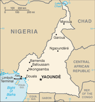
Cameroon_CIA_WFB_2006_map.png (328 × 352 piksela, veličina datoteke: 10 KB, MIME tip: image/png)
| Ova datoteka je s Wikimedia Commonsa. Opis s njene stranice opisa datoteke prikazan je ispod. Commons je skladište slobodnih medija i datoteka za sve projekte fondacije Wikimedia. Možete i Vi pomoći. |
Sažetak
| Opis | Cameroon map from CIA World Factbook (since 10 maj 2006), converted from original GIF format |
| Datum | |
| Izvor |
CIA World Factbook |
| Autor | United States Central Intelligence Agency |
| Ostale verzije |
|
Licenciranje
This image is in the public domain because it contains materials that originally came from the United States Central Intelligence Agency's World Factbook.
|
 |
Derivative works
Derivatives of 2006 map:
-
 Mapa kamerunu.png
čeština

Derivatives of 2002 map:
-
 Camerunit.png
italiano -
 Carte cameroun francais.gif
français -
 Kameroenkaart.png
Afrikaans -
 000 Kameruni harta.PNG
 -
 Cameroon-map-blank.png


Derivatives of 2000 map:
-
 Southern cameroon map.JPG

Historija datoteke
Kliknite na datum/vrijeme da vidite verziju datoteke iz tog vremena.
| Datum/vrijeme | Smanjeni pregled | Dimenzije | Korisnik | Komentar | |
|---|---|---|---|---|---|
| trenutno | 08:34, 2 septembar 2011 | | 328 × 352 (10 KB) | Zyxw | == {{int:filedesc}} == {{Information | Description = {{w|Cameroon}} map from CIA World Factbook ([http://web.archive.org/web/20060510034911/http://www.cia.gov/cia/publications/factbook/geos/cm.html since {{date|2006|05|10}}]), converted from original {{w| |
Upotreba datoteke
Sljedeća stranica koristi ovu datoteku:
Globalna upotreba datoteke
Sljedeći wikiji koriste ovu datoteku:
- Upotreba na bn.wikipedia.org
- Upotreba na ca.wikipedia.org
- Upotreba na en.wikipedia.org
- Upotreba na eo.wikipedia.org
- Upotreba na fa.wikipedia.org
- Upotreba na fi.wikipedia.org
- Upotreba na fr.wikipedia.org
- Upotreba na ilo.wikipedia.org
- Upotreba na ja.wikipedia.org
- Upotreba na kn.wikipedia.org
- Upotreba na ml.wikipedia.org
- Upotreba na simple.wikipedia.org
- Upotreba na si.wikipedia.org
- Upotreba na sl.wikipedia.org
- Upotreba na sn.wikipedia.org
- Upotreba na th.wikipedia.org
- Upotreba na tl.wikipedia.org
- Upotreba na uz.wikipedia.org
- Upotreba na zh.wikipedia.org