
Datoteka:Canada geological map.JPG

Veličina ovog prikaza: 770 × 599 piksela. Ostale rezolucije: 308 × 240 piksela | 617 × 480 piksela | 987 × 768 piksela | 1.280 × 996 piksela | 2.000 × 1.557 piksela.
Izvorna datoteka (2.000 × 1.557 piksela, veličina datoteke: 2,25 MB, MIME tip: image/jpeg)
| Ova datoteka je s Wikimedia Commonsa. Opis s njene stranice opisa datoteke prikazan je ispod. Commons je skladište slobodnih medija i datoteka za sve projekte fondacije Wikimedia. Možete i Vi pomoći. |

|
This geology image could be re-created using vector graphics as an SVG file. This has several advantages; see Commons:Media for cleanup for more information. If an SVG form of this image is available, please upload it and afterwards replace this template with
{{vector version available|new image name}}.
It is recommended to name the SVG file “Canada geological map.svg”—then the template Vector version available (or Vva) does not need the new image name parameter. |


Sažetak
| Opis |
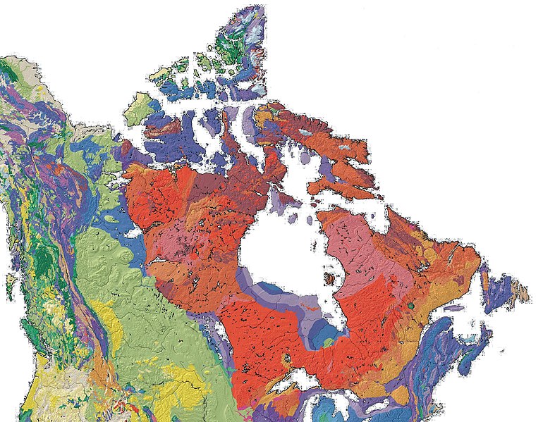
English: Geological Map of Canada |
| Datum | |
| Izvor | en:File:North america with-Williston.jpg, PD - USGS |
| Autor | Qyd |
Licenciranje
| Ja, vlasnik autorskog prava ovog djela, objavljujem ovaj rad u javno vlasništvo. Ovo se primjenjuje u cijelom svijetu. U nekim državama ovo zakonski nije moguće; u tom slučaju: Ja dopuštam svima pravo korištenja ovog rada u bilo koju svrhu, bez ikakvih uslova, osim ako su takvi uslovi zakonski neophodni. |
Historija datoteke
Kliknite na datum/vrijeme da vidite verziju datoteke iz tog vremena.
| Datum/vrijeme | Smanjeni pregled | Dimenzije | Korisnik | Komentar | |
|---|---|---|---|---|---|
| trenutno | 18:23, 6 mart 2009 | | 2.000 × 1.557 (2,25 MB) | Qyd | {{Information |Description={{en|1=Geological Map of Canada}} |Source=File:North america with-Williston.jpg, PD - USGS |Author=Qyd |Date=2009 |Permission= |other_versions= }} Category:Maps of Canada <!--{{ImageUpload|full}}--> |
Upotreba datoteke
Sljedeća stranica koristi ovu datoteku:
Globalna upotreba datoteke
Sljedeći wikiji koriste ovu datoteku:
- Upotreba na be.wikipedia.org
- Upotreba na bg.wikipedia.org
- Upotreba na bn.wikipedia.org
- Upotreba na cs.wikipedia.org
- Upotreba na de.wikipedia.org
- Upotreba na en.wikipedia.org
- Upotreba na en.wikiversity.org
- Upotreba na en.wikivoyage.org
- Upotreba na fa.wikipedia.org
- Upotreba na fr.wikipedia.org
- Upotreba na gcr.wikipedia.org
- Upotreba na he.wikipedia.org
- Upotreba na he.wiktionary.org
- Upotreba na hu.wikipedia.org
- Upotreba na id.wikipedia.org
- Upotreba na ja.wikipedia.org
- Upotreba na pl.wikipedia.org
- Upotreba na ru.wikipedia.org
- Upotreba na sh.wikipedia.org
- Upotreba na simple.wikipedia.org
- Upotreba na sk.wikipedia.org
- Upotreba na uk.wikipedia.org
- Upotreba na zh-yue.wikipedia.org
- Upotreba na zh.wikipedia.org