
Datoteka:ElectoralCollege2016.svg

Izvorna datoteka (SVG datoteka, nominalno 1.020 × 593 piksela, veličina datoteke: 30 KB)
| Ova datoteka je s Wikimedia Commonsa. Opis s njene stranice opisa datoteke prikazan je ispod. Commons je skladište slobodnih medija i datoteka za sve projekte fondacije Wikimedia. Možete i Vi pomoći. |
| U.S. presidential election maps (SVG) |
| See also: National Atlas maps (png) |
|
1789 · 1792 · 1796 · 1800 · 1804 · 1808 · 1812 · 1816 · 1820 · 1824 · 1828 · 1832 · 1836 · 1840 · 1844 · 1848 · 1852 · 1856 · 1860 · 1864 · 1868 · 1872 · 1876 · 1880 · 1884 · 1888 · 1892 · 1896 · 1900 · 1904 · 1908 · 1912 · 1916 · 1920 · 1924 · 1928 · 1932 · 1936 · 1940 · 1944 · 1948 · 1952 · 1956 · 1960 · 1964 · 1968 · 1972 · 1976 · 1980 · 1984 · 1988 · 1992 · 1996 · 2000 · 2004 · 2008 · 2012 · 2016 · 2020 · 2024 |
Sažetak
| Opis |
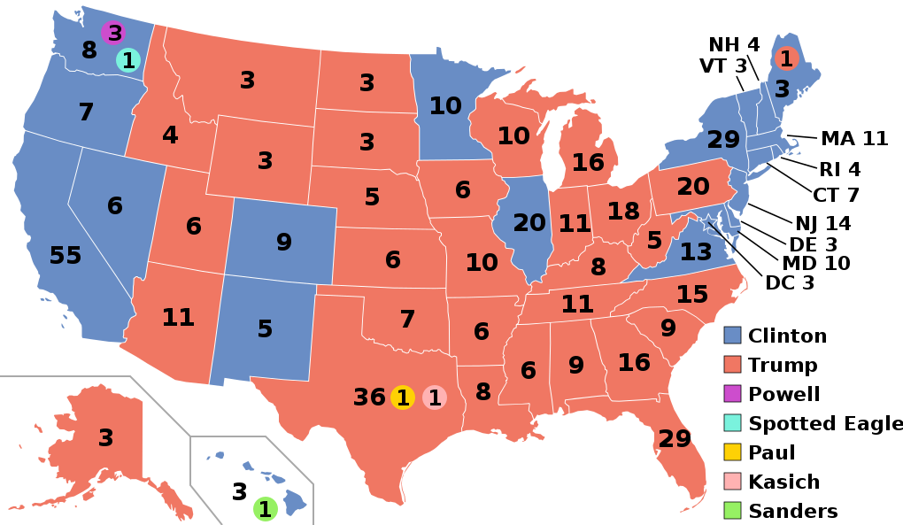
English: Electoral college map for the 2016 United States presidential election (note: Nebraska and Maine split their EVs by congressional district). |
||||
| Datum | |||||
| Izvor | 2012 Electoral College map | ||||
| Autor | Gage | ||||
| Ostale verzije |
|
||||
| SVG genesis |

.svg)


.svg)
.svg)


Licenciranje
- Slobodni ste:
- da dijelite – da kopirate, distributirate i prenosite djelo
- da remiksate – da prilagodite djelo
- Pod sljedećim uslovima:
- pripisivanje – Morate pripisati odgovarajuće autorske zasluge, osigurati link ka licenci i naznačiti jesu li napravljene izmjene. To možete uraditi na bilo koji razumni način, ali ne tako da se sugerira da davalac licence odobrava Vas ili Vašu upotrebu njegovog djela.
- dijeli pod istim uslovima – Ako mijenjate, transformišete ili nadograđujete ovaj materijal, morate ga objaviti i distribuirati samo pod istom ili sličnom licencom poput ove.
Historija datoteke
Kliknite na datum/vrijeme da vidite verziju datoteke iz tog vremena.
| Datum/vrijeme | Smanjeni pregled | Dimenzije | Korisnik | Komentar | |
|---|---|---|---|---|---|
| trenutno | 05:22, 27 novembar 2020 | | 1.020 × 593 (30 KB) | Politicsfan4 | Updated placement of ME-2's electoral vote for consistency with 2020 map |
| 03:22, 5 august 2020 |  | 1.020 × 593 (30 KB) | Nojus R | Reverted to version as of 07:42, 13 January 2019 (UTC) it looks so weird when every other map uses a different font | |
| 21:31, 10 decembar 2019 |  | 1.020 × 593 (30 KB) | IagoQnsi | switching font to Arial, as it looks less-ugly in the server-side rendering // Editing SVG source code using c:User:Rillke/SVGedit.js | |
| 09:42, 13 januar 2019 |  | 1.020 × 593 (30 KB) | Newfraferz87 | (minor) | |
| 04:50, 20 novembar 2018 |  | 1.020 × 593 (30 KB) | Newfraferz87 | *DC | |
| 04:35, 20 novembar 2018 |  | 1.020 × 593 (30 KB) | Newfraferz87 | Simplify further: coordinates & fills, following this | |
| 16:16, 18 januar 2017 |  | 1.020 × 593 (36 KB) | Newfraferz87 | Shrink size using relative line coordinates. Thanks for the border corrections. | |
| 11:20, 17 januar 2017 |  | 1.020 × 593 (43 KB) | Karlfk | Better borderlines, esp. OH/WV/PA triangle or ID/MT border | |
| 05:14, 12 januar 2017 |  | 1.020 × 593 (36 KB) | PalmerTheGolfer | Reverted to version as of 00:56, 3 January 2017 (UTC) Font of numbers and State line consistency with prior elections more important than a non-existent Libretarian faithless elector change | |
| 00:50, 11 januar 2017 |  | 1.020 × 593 (36 KB) | Maproom | Changed font to Liberation Sans, in the hope of avoiding the problem of "Eagle" extending off the end of the image |
.svg)
Upotreba datoteke
Sljedeće 2 stranice koriste ovu datoteku:
Globalna upotreba datoteke
Sljedeći wikiji koriste ovu datoteku:
- Upotreba na af.wikipedia.org
- Upotreba na ang.wikipedia.org
- Upotreba na ar.wikipedia.org
- Upotreba na arz.wikipedia.org
- Upotreba na be.wikipedia.org
- Upotreba na bg.wikipedia.org
- Upotreba na bn.wikipedia.org
- Upotreba na ca.wikipedia.org
- Upotreba na cdo.wikipedia.org
- Upotreba na cs.wikipedia.org
- Upotreba na cy.wikipedia.org
- Upotreba na da.wikipedia.org
- Upotreba na de.wikipedia.org
- Upotreba na dty.wikipedia.org
- Upotreba na el.wikipedia.org
- Upotreba na en.wikipedia.org
- Donald Trump
- Electoral vote changes between United States presidential elections
- List of United States presidential election results by state
- Presidency of Barack Obama
- 2016 United States presidential election
- United States presidential election
- 2016 Democratic Party presidential candidates
- 2016 Democratic Party presidential primaries
- 2016 Republican Party presidential candidates
- 2016 Republican Party presidential primaries
- Third party and independent candidates for the 2016 United States presidential election
- 2016 United States elections
- User:ArcMachaon/sandbox
- User:Mandruss/sandbox
- User:Visigoethe/sandbox
- User:Machinekng/sandbox
- Donald Trump 2016 presidential campaign
- 2016 New Hampshire Republican presidential primary
Pogledajte globalne upotrebe ove datoteke.