Datoteka:Gibraltar map-en.svg
Sadržaj stranice nije podržan na drugim jezicima.
S Wikipedije, slobodne enciklopedije

Izvorna datoteka(SVG datoteka, nominalno 2.020 × 3.140 piksela, veličina datoteke: 289 KB)

Slika of the year
Slika of the year
Featured slika

Wikimedia Commons

This file was a candidate in Picture of the Year 2007.
This is a featured picture on Wikimedia Commons (Featured pictures) and is considered one of the finest images. See its nomination here.

If you have an image of similar quality that can be published under a suitable copyright license, be sure to upload it, tag it, and nominate it.

Sažetak

Camera location36° 08′ 00″ N, 5° 21′ 00″ W Kartographer map based on OpenStreetMap.View this and other nearby images on: OpenStreetMapinfo
Opis
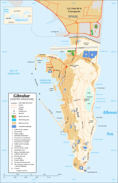
Čeština: Mapa ostrova Gibraltar v angličtině.
English: Map in English of Gibraltar.
Français : * Sujet : Carte en anglais de Gibraltar ;
  • Sources : Création personnelle ;
  • Carte créée à partir de captures d'écran d'images satellite de Google Earth d'un point de vue placé à 1,18 km d'altitude (imagerie disponible de novembre 2007) ;
  • Références complémentaires :
  • Échelle approximative : 1:40 000 (précision : environ 10 m) ;
  • Note : Largeur du tracé des routes proportionnelle à la réalité ;
  • Auteur : Eric Gaba (fr:Sting) ;
  • Date : Novembre 2007.
Português: Mapa (em Inglês) de Gibraltar.
Datum
Izvor Own work ;
Map created using screenshots of Google Earth satellite imagery from a point of view located at 1.18 km of altitude (available imagery of November 2007) ;
Other references :
* CIA map ;
* Gibnet map ;
* U.K. MoD map
Locator map : Image:Blank_map_of_South_Europe_and_North_Africa.svg (modified) created by Historicair ;
Approximate scale : 1:40,000 (accuracy : about 10 m)
Note : The roads width is proportional to reality
Autor Eric Gaba (Sting)
Dopuštenje
(Naknadno korištenje ove datoteke)
Attribution and Share-Alike required
Ostale verzije

[uredi]

Disputed isthmus and land
SVG genesis
InfoField
 
The SVG code is valid.
 
This map was created with Inkscape…important.
 
 This map uses embedded text that can be easily translated using a text editor.

Licenciranje

Ja, vlasnik autorskog prava ovog djela, ovdje ga objavljujem pod sljedećim licencama:
GNU head Dozvoljeno je kopirati, distribuirati i/ili mijenjati ovaj članak pod uslovima navedenim u GNU licenci za slobodnu dokumentaciju, verzija 1.2 ili kasnijom verzijom izdatom od Free Software Foundation; bez nepromjenljivih dijelova, te bez sadržaja na naslovnoj i zadnjoj strani. Kopija licence se nalazi pod poglavljem GNU Free Documentation License.
w:bs:Creative Commons
pripisivanje dijeli pod istim uslovima
This file is licensed under the Creative Commons Attribution-Share Alike Attribution-Share Alike 4.0 International, 3.0 Unported, 2.5 Generic, 2.0 Generic and 1.0 Generic license.
Slobodni ste:
  • da dijelite – da kopirate, distributirate i prenosite djelo
  • da remiksate – da prilagodite djelo
Pod sljedećim uslovima:
  • pripisivanje – Morate pripisati odgovarajuće autorske zasluge, osigurati link ka licenci i naznačiti jesu li napravljene izmjene. To možete uraditi na bilo koji razumni način, ali ne tako da se sugerira da davalac licence odobrava Vas ili Vašu upotrebu njegovog djela.
  • dijeli pod istim uslovima – Ako mijenjate, transformišete ili nadograđujete ovaj materijal, morate ga objaviti i distribuirati samo pod istom ili sličnom licencom poput ove.
Možete odabrati licencu po vašem izboru.

Captions

Add a one-line explanation of what this file represents

Items portrayed in this file

prikazuje

36°7'59.999"N, 5°21'0.000"W

media type engleski

image/svg+xml

Historija datoteke

Kliknite na datum/vrijeme da vidite verziju datoteke iz tog vremena.

Datum/vrijemeSmanjeni pregledDimenzijeKorisnikKomentar
trenutno22:10, 21 februar 2020Smanjeni pregled verzije na dan 22:10, 21 februar 20202.020 × 3.140 (289 KB)JoKalliauermalformed svg (compare firefox/chrome rendering with librsvg-rendering) actually firefox/chrome were correct, also it looks wrong
08:01, 29 juni 2017Smanjeni pregled verzije na dan 08:01, 29 juni 20172.020 × 3.140 (538 KB)Wereldburger758Removal error in file. Valid SVG now.
23:52, 27 august 2008Smanjeni pregled verzije na dan 23:52, 27 august 20082.020 × 3.140 (569 KB)RedCoatRemove "claimed by Spain", completely gratuitous for a map
13:28, 11 decembar 2007Smanjeni pregled verzije na dan 13:28, 11 decembar 20072.020 × 3.140 (570 KB)StingNotification of the Spanish claims
16:40, 27 novembar 2007Smanjeni pregled verzije na dan 16:40, 27 novembar 20072.020 × 3.140 (569 KB)StingAdditional names ; up-to-date corrections
23:35, 26 novembar 2007Smanjeni pregled verzije na dan 23:35, 26 novembar 20072.020 × 3.140 (561 KB)RedCoatHouse of Assembly → Gibraltar Parliament
21:51, 26 novembar 2007Smanjeni pregled verzije na dan 21:51, 26 novembar 20072.020 × 3.140 (561 KB)Sting+ info
16:12, 26 novembar 2007Smanjeni pregled verzije na dan 16:12, 26 novembar 20072.020 × 3.140 (561 KB)Sting+ info
15:21, 26 novembar 2007Smanjeni pregled verzije na dan 15:21, 26 novembar 20072.020 × 3.140 (561 KB)Sting{{Information |Description=Map in English of Gibraltar |Source=Own work ;<br/>Map created using screenshots of Google Earth satellite imagery from a point of view located at 1.18 km of altitude (available image

Nema stranica koje koriste ovu datoteku.

Globalna upotreba datoteke

Sljedeći wikiji koriste ovu datoteku:

Metapodaci