
Datoteka:Madhhab Map2.png
Veličina ovog prikaza: 800 × 388 piksela. Ostale rezolucije: 320 × 155 piksela | 640 × 310 piksela | 1.245 × 604 piksela.
Izvorna datoteka (1.245 × 604 piksela, veličina datoteke: 50 KB, MIME tip: image/png)
| Ova datoteka je s Wikimedia Commonsa. Opis s njene stranice opisa datoteke prikazan je ispod. Commons je skladište slobodnih medija i datoteka za sve projekte fondacije Wikimedia. Možete i Vi pomoći. |

|
This religion map image could be re-created using vector graphics as an SVG file. This has several advantages; see Commons:Media for cleanup for more information. If an SVG form of this image is available, please upload it and afterwards replace this template with
{{vector version available|new image name}}.
It is recommended to name the SVG file “Madhhab Map2.svg”—then the template Vector version available (or Vva) does not need the new image name parameter. |
Sažetak
| Opis |
العربية: المدارس الفقهية الإسلامية الرئيسيّة وانتشارها حول العالم (لغة إنجليزية)
فارسی: نقشهٔ پراکندگی مذاهب فقهی اسلام در جهان (انگلیسی)
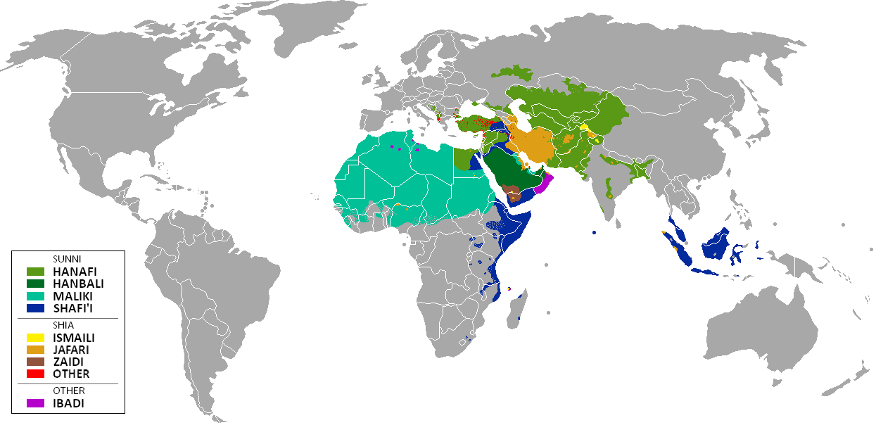
English: The distribution of the predominant Islamic madhhab (school of law) followed in majority-Muslim countries and regions (English)
Bahasa Indonesia: Distribusi penyebaran agama islam berdasarkan Mahdab di negara-negara dan wilayah dunia |
| Datum | |
| Izvor | Own work by uploader from a blank-map, based on this source: Legal Sources and various other sources |
| Autor | Ghibar |
| Ostale verzije |
Derivative works of this file: |
Licenciranje
Ja, vlasnik autorskog prava ovog djela, ovdje ga objavljujem pod sljedećim licencama:
Ova datoteka je licencirana pod Creative Commons Attribution-Share Alike 3.0 neportiranom licencom.
- Slobodni ste:
- da dijelite – da kopirate, distributirate i prenosite djelo
- da remiksate – da prilagodite djelo
- Pod sljedećim uslovima:
- pripisivanje – Morate pripisati odgovarajuće autorske zasluge, osigurati link ka licenci i naznačiti jesu li napravljene izmjene. To možete uraditi na bilo koji razumni način, ali ne tako da se sugerira da davalac licence odobrava Vas ili Vašu upotrebu njegovog djela.
- dijeli pod istim uslovima – Ako mijenjate, transformišete ili nadograđujete ovaj materijal, morate ga objaviti i distribuirati samo pod istom ili sličnom licencom poput ove.

|
Dozvoljeno je kopirati, distribuirati i/ili mijenjati ovaj članak pod uslovima navedenim u GNU licenci za slobodnu dokumentaciju, verzija 1.2 ili kasnijom verzijom izdatom od Free Software Foundation; bez nepromjenljivih dijelova, te bez sadržaja na naslovnoj i zadnjoj strani. Kopija licence se nalazi pod poglavljem GNU Free Documentation License. |
Možete odabrati licencu po vašem izboru.
| Annotations | This image is annotated: View the annotations at Commons |
Historija datoteke
Kliknite na datum/vrijeme da vidite verziju datoteke iz tog vremena.
| Datum/vrijeme | Smanjeni pregled | Dimenzije | Korisnik | Komentar | |
|---|---|---|---|---|---|
| trenutno | 13:24, 23 januar 2018 | | 1.245 × 604 (50 KB) | Maphobbyist | Revert. Jafari school more widespread in northern Sumatra according to sources, than mere dots. |
| 13:55, 30 maj 2016 |  | 1.245 × 604 (2,87 MB) | Riyantojayadi | Madhhab majority of Aceh region[1] and West Sumatra/Minangkabau region[2] in Indonesia are Syafii school of Sunni. There are some tribe's ritual in this area that are based on Shia such tabot, however, for religion, they are practicing . Shia communiti... | |
| 15:45, 11 januar 2015 |  | 1.245 × 604 (50 KB) | AnonMoos | Reverted to version as of 02:11, 30 July 2014 -- see User_talk:Peaceworld111 | |
| 12:24, 11 januar 2015 |  | 1.245 × 604 (52 KB) | Peaceworld111 | Re-added Ahmadi. It's a sect of Islam per reliable sources and is not a mere dot. See talk page. | |
| 04:10, 11 januar 2015 |  | 1.245 × 604 (50 KB) | AnonMoos | Reverted to version as of 02:11, 30 July 2014 -- change not discussed on image talk page, possibly problematic, see user talk page | |
| 20:11, 8 januar 2015 |  | 1.245 × 604 (52 KB) | Peaceworld111 | Added Ahmadi | |
| 04:11, 30 juli 2014 |  | 1.245 × 604 (50 KB) | KronosLine | Fixed Russia | |
| 20:36, 20 juli 2014 |  | 1.245 × 604 (63 KB) | Calthinus | distribution of Bektashis in Albania fixed, distribution of Muslims in Greece & Macedonia (esp the ethnic Slav Macedonian Muslims, whose distribution had previously not been marked) fixed, various other fixes... | |
| 19:50, 19 oktobar 2013 |  | 1.245 × 604 (50 KB) | Hibernian | Damn it, that revert button doesn't do what I thought it does. Here's what I meant to change it to. This version also changes the Kerala Muslims to Shafi'i as was suggested on the talk page. | |
| 19:37, 19 oktobar 2013 |  | 1.245 × 604 (55 KB) | Hibernian | Reverted to previous version. It is totally illogical to not show the borders of states with limited recognition (practically every map on Wikipedia depicts these entities), it has nothing to do with the official UN definitions, but with showing reality. |
Upotreba datoteke
Nema stranica koje koriste ovu datoteku.
Globalna upotreba datoteke
Sljedeći wikiji koriste ovu datoteku:
- Upotreba na bn.wikipedia.org
- Upotreba na bn.wikivoyage.org
- Upotreba na en.wikipedia.org
- Upotreba na en.wikivoyage.org
- Upotreba na he.wikipedia.org
- Upotreba na hi.wikivoyage.org
- Upotreba na id.wikipedia.org
- Upotreba na incubator.wikimedia.org
- Upotreba na it.wikivoyage.org
- Upotreba na ja.wikipedia.org
- Upotreba na mzn.wikipedia.org
- Upotreba na uk.wikipedia.org