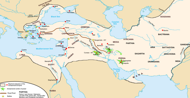
Datoteka:Map achaemenid empire en.png

Veličina ovog prikaza: 800 × 415 piksela. Ostale rezolucije: 320 × 166 piksela | 640 × 332 piksela | 1.024 × 531 piksela | 1.676 × 869 piksela.
Izvorna datoteka (1.676 × 869 piksela, veličina datoteke: 376 KB, MIME tip: image/png)
Historija datoteke
Kliknite na datum/vrijeme da vidite verziju datoteke iz tog vremena.
| Datum/vrijeme | Smanjeni pregled | Dimenzije | Korisnik | Komentar | |
|---|---|---|---|---|---|
| trenutno | 06:35, 19 novembar 2017 |  | 1.676 × 869 (376 KB) | R9tgokunks | Reverted to version as of 00:35, 14 October 2015 (UTC) |
| 10:36, 24 oktobar 2017 |  | 1.676 × 869 (450 KB) | Mehrdad 12 | Reverted to version as of 21:38, 10 August 2015 (UTC) | |
| 02:35, 14 oktobar 2015 |  | 1.676 × 869 (376 KB) | LouisAragon | For the last time; they did NOT conquer territoiry past the Indus River border as of on this map. | |
| 02:02, 12 oktobar 2015 |  | 1.676 × 864 (484 KB) | History of Persia | Macedonia | |
| 01:58, 12 oktobar 2015 |  | 1.676 × 869 (446 KB) | History of Persia | Yeah their included but the borders are innacurrate. Arabia extended deeper and the indus river itself was not the border itself. | |
| 04:33, 11 oktobar 2015 |  | 1.676 × 869 (376 KB) | LouisAragon | The Indus and Northern Arabia are already included. Bring your concerns (with sources) to the Wikipedia talk page. | |
| 06:45, 14 august 2015 |  | 1.676 × 869 (446 KB) | History of Persia | better | |
| 23:38, 10 august 2015 |  | 1.676 × 869 (450 KB) | History of Persia | darius conquered the indus and arabia | |
| 23:38, 10 august 2015 |  | 1.676 × 869 (450 KB) | History of Persia | darius conquered the indus and arabia | |
| 23:37, 10 august 2015 |  | 1.676 × 869 (450 KB) | History of Persia | darius conquered the indus and arabia |
Upotreba datoteke
Sljedeća stranica koristi ovu datoteku:
Globalna upotreba datoteke
Sljedeći wikiji koriste ovu datoteku:
- Upotreba na als.wikipedia.org
- Upotreba na ar.wikipedia.org
- Upotreba na ast.wikipedia.org
- Upotreba na av.wikipedia.org
- Upotreba na azb.wikipedia.org
- Upotreba na az.wikipedia.org
- Upotreba na ba.wikipedia.org
- Upotreba na be.wikipedia.org
- Upotreba na bg.wikipedia.org
- Upotreba na bxr.wikipedia.org
- Upotreba na ca.wikipedia.org
- Upotreba na cs.wikipedia.org
- Upotreba na de.wikipedia.org
- Upotreba na diq.wikipedia.org
- Upotreba na el.wikipedia.org
- Upotreba na en.wikipedia.org
- Empire
- Talk:Iran/Archive 10
- Timeline of Jerusalem
- List of conflicts in Asia
- User talk:SG/Archive1
- Template talk:History of Afghanistan
- User:Ottava Rima/Persian Empire
- User:John K/Persian Empire
- Talk:Achaemenid Empire/Archive 1
- List of ancient great powers
- User:Falcaorib
- Wikipedia:Graphics Lab/Map workshop/Archive/Mar 2020
- Upotreba na en.wikibooks.org
- Upotreba na en.wiktionary.org
- Upotreba na eo.wikipedia.org
- Upotreba na es.wikipedia.org
- Upotreba na eu.wikipedia.org
Pogledajte globalne upotrebe ove datoteke.


