
Datoteka:NUTS 3 regions of North East England map.svg

Veličina ovog PNG pregleda za ovu SVG datoteku: 482 × 599 piksela. Ostale rezolucije: 193 × 240 piksela | 386 × 480 piksela | 618 × 768 piksela | 824 × 1.024 piksela | 1.647 × 2.048 piksela | 1.082 × 1.345 piksela.
Izvorna datoteka (SVG datoteka, nominalno 1.082 × 1.345 piksela, veličina datoteke: 714 KB)
| Ova datoteka je s Wikimedia Commonsa. Opis s njene stranice opisa datoteke prikazan je ispod. Commons je skladište slobodnih medija i datoteka za sve projekte fondacije Wikimedia. Možete i Vi pomoći. |
Sažetak
| Opis |
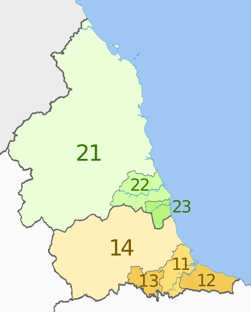
English: Map of the NUTS 3 regions of North East England.
Equirectangular map projection on WGS 84 datum, with N/S stretched 170% Geographic limits:
|
| Datum | (UTC) |
| Izvor |
This file was derived from: |
| Autor |
|


| NUTS 1 | Code | NUTS 2 | Code | NUTS 3 | Code |
|---|---|---|---|---|---|
| North East, England | UKC | Tees Valley and Durham | UKC1 | Hartlepool and Stockton-on-Tees | UKC11 |
| South Teesside (Middlesbrough and Redcar and Cleveland) | UKC12 | ||||
| Darlington | UKC13 | ||||
| Durham | UKC14 | ||||
| Northumberland and Tyne and Wear | UKC2 | ||||
| Northumberland | UKC21 | ||||
| Tyneside (Newcastle upon Tyne, Gateshead, South Tyneside, North Tyneside) | UKC22 | ||||
| Sunderland | UKC23 |
Licenciranje
Ova datoteka je licencirana pod Creative Commons Attribution-Share Alike 3.0 neportiranom licencom.
Pripisivanje: Dr Greg and Nilfanion. Contains Ordnance Survey data © Crown copyright and database right 2011
- Slobodni ste:
- da dijelite – da kopirate, distributirate i prenosite djelo
- da remiksate – da prilagodite djelo
- Pod sljedećim uslovima:
- pripisivanje – Morate pripisati odgovarajuće autorske zasluge, osigurati link ka licenci i naznačiti jesu li napravljene izmjene. To možete uraditi na bilo koji razumni način, ali ne tako da se sugerira da davalac licence odobrava Vas ili Vašu upotrebu njegovog djela.
- dijeli pod istim uslovima – Ako mijenjate, transformišete ili nadograđujete ovaj materijal, morate ga objaviti i distribuirati samo pod istom ili sličnom licencom poput ove.
Originalni zapisnik postavljanja
This image is a derivative work of the following images:
- File:North_East_England__districts_2011_map.svg licensed with Cc-by-sa-3.0, GFDL
- 2011-05-01T18:56:43Z Nilfanion 1082x1345 (714062 Bytes) == Summary == {{Information |Description=Map of the [[w:North East England|North East England]] region showing the administrative districts. Equirectangular map projection on WGS 84 datum, with N/S stretched 170% Geographic
- File:English_ceremonial_counties_2010.svg licensed with Cc-by-sa-3.0, GFDL
- 2010-11-23T16:39:55Z Nilfanion 1108x1345 (308868 Bytes) thicker lines
- 2010-11-23T16:20:19Z Nilfanion 1108x1345 (301520 Bytes) tweaks
- 2010-10-26T20:34:20Z Nilfanion 817x990 (1391832 Bytes) {{Information |Description=Map showing the [[w:ceremonial counties of England]] including the City of London, in 2010. Equirectangular map projection on WGS 84 datum, with N/S stretched 170% Geographic limits: *West: 6.75W
Uploaded with derivativeFX
Historija datoteke
Kliknite na datum/vrijeme da vidite verziju datoteke iz tog vremena.
| Datum/vrijeme | Smanjeni pregled | Dimenzije | Korisnik | Komentar | |
|---|---|---|---|---|---|
| trenutno | 23:27, 4 juni 2012 | | 1.082 × 1.345 (714 KB) | Dr Greg | == {{int:filedesc}} == {{Information |Description=Map of the NUTS 3 regions of North East England. Equirectangular map projection on WGS 84 datum, with N/S stretched 170... |
Upotreba datoteke
Nema stranica koje koriste ovu datoteku.
Globalna upotreba datoteke
Sljedeći wikiji koriste ovu datoteku:
- Upotreba na bn.wikipedia.org
- Upotreba na de.wikipedia.org
- Upotreba na en.wikipedia.org
- Upotreba na fi.wikipedia.org
- Upotreba na it.wikipedia.org
- Upotreba na lt.wikipedia.org
- Upotreba na ru.wikipedia.org
- Upotreba na zh.wikipedia.org