
Datoteka:Prague municipal districts.png

Veličina ovog prikaza: 776 × 600 piksela. Ostale rezolucije: 311 × 240 piksela | 621 × 480 piksela | 994 × 768 piksela | 1.056 × 816 piksela.
Izvorna datoteka (1.056 × 816 piksela, veličina datoteke: 69 KB, MIME tip: image/png)
| Ova datoteka je s Wikimedia Commonsa. Opis s njene stranice opisa datoteke prikazan je ispod. Commons je skladište slobodnih medija i datoteka za sve projekte fondacije Wikimedia. Možete i Vi pomoći. |

|
This locator map image could be re-created using vector graphics as an SVG file. This has several advantages; see Commons:Media for cleanup for more information. If an SVG form of this image is available, please upload it and afterwards replace this template with
{{vector version available|new image name}}.
It is recommended to name the SVG file “Prague municipal districts.svg”—then the template Vector version available (or Vva) does not need the new image name parameter. |
Sažetak
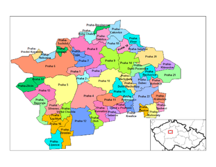
Map of the municipal districts of Prague in the Czech Republic. Created by Rarelibra 15:16, 2 January 2007 (UTC) for public domain use, using MapInfo Professional v8.5 and various mapping resources.
Licenciranje
| Ja, vlasnik autorskog prava ovog djela, objavljujem ovaj rad u javno vlasništvo. Ovo se primjenjuje u cijelom svijetu. U nekim državama ovo zakonski nije moguće; u tom slučaju: Ja dopuštam svima pravo korištenja ovog rada u bilo koju svrhu, bez ikakvih uslova, osim ako su takvi uslovi zakonski neophodni. |
Historija datoteke
Kliknite na datum/vrijeme da vidite verziju datoteke iz tog vremena.
| Datum/vrijeme | Smanjeni pregled | Dimenzije | Korisnik | Komentar | |
|---|---|---|---|---|---|
| trenutno | 12:47, 1 april 2007 | | 1.056 × 816 (69 KB) | Kirk979 | |
| 17:16, 2 januar 2007 |  | 1.056 × 816 (70 KB) | Rarelibra | Map of the municipal districts of Prague in the Czech Republic. Created by ~~~~ for public domain use, using MapInfo Professional v8.5 and various mapping resources. |
Upotreba datoteke
Sljedeće 2 stranice koriste ovu datoteku:
Globalna upotreba datoteke
Sljedeći wikiji koriste ovu datoteku:
- Upotreba na als.wikipedia.org
- Upotreba na bg.wikipedia.org
- Upotreba na cs.wikipedia.org
- Upotreba na en.wikipedia.org
- Upotreba na eo.wikipedia.org
- Upotreba na es.wikipedia.org
- Upotreba na fr.wikipedia.org
- Upotreba na nl.wikipedia.org
- Upotreba na pl.wikipedia.org
- Upotreba na ro.wikipedia.org
- Upotreba na ru.wikipedia.org
- Upotreba na sk.wikipedia.org