
Datoteka:VelikiStol Mountain from Slovenia.jpg
Izvorna datoteka (2.600 × 1.726 piksela, veličina datoteke: 2,75 MB, MIME tip: image/jpeg)
| Ova datoteka je s Wikimedia Commonsa. Opis s njene stranice opisa datoteke prikazan je ispod. Commons je skladište slobodnih medija i datoteka za sve projekte fondacije Wikimedia. Možete i Vi pomoći. |
|

|
This image has been assessed under the valued image criteria and is considered the most valued image on Commons within the scope: Veliki Stol (Hochstuhl) Mountain. You can see its nomination here. |
This image has been assessed using the Quality image guidelines and is considered a Quality image.
|
Sažetak
| Opis |
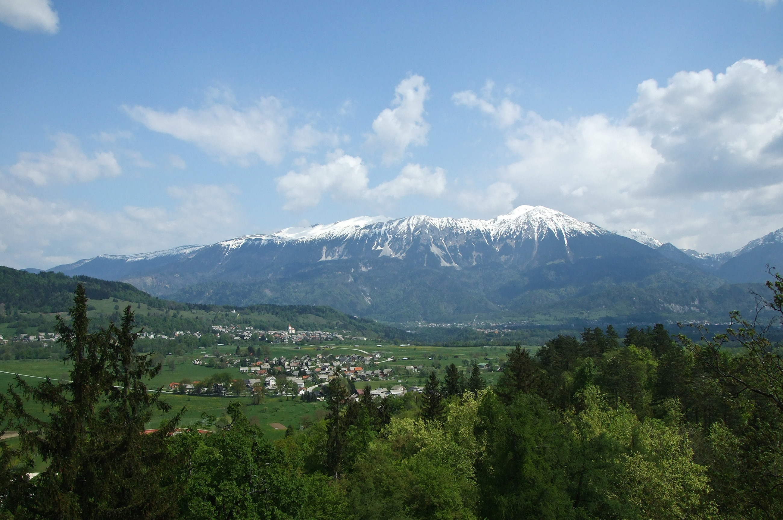
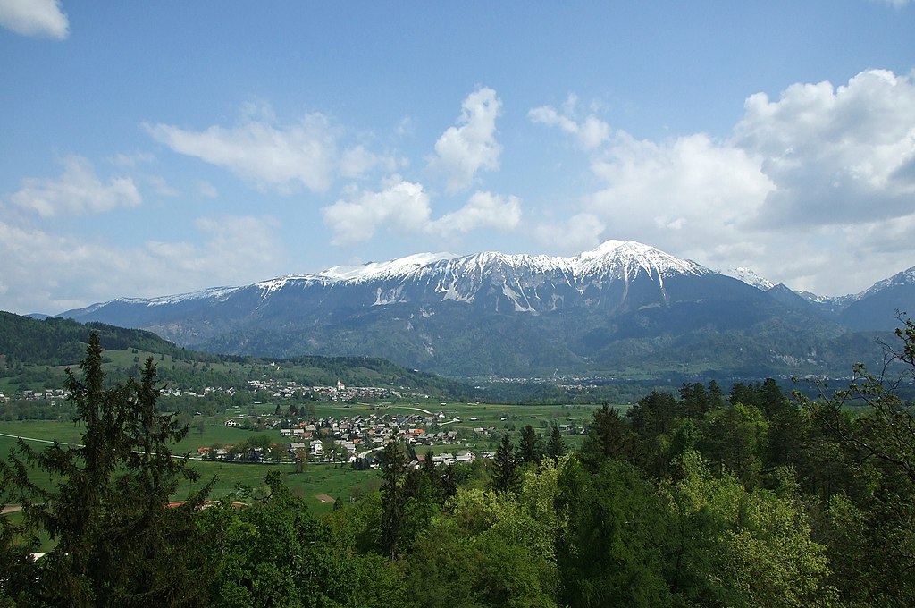
English: Veliki Stol Mountain, part of Karavanke range, as seen from the Bled Castle, Slovenia. The highest peak Stol (Hochstuhl) with its 2,236 m (7,336 ft) can be seen on the right. In the foreground the suburbs of Bled town can be also seen as well as Zasip village with its Parish Church of Saint John the Baptist. The Sava Dolinka valley spreads between the settlements and the mountain. The mountain ridge defines the border between Slovenia and Austria.
Français : Le mont Stol, un sommet de la chaine des Karavanke, vu depuis le château de Bled, en Slovénie. La crête de cette chaine constitue la frontière entre la Slovénie et l'Autriche. Au premier plan, la périphérie de Bled est visible devant le village de Zasip
Slovenščina: Gora Stol v Karavankah, pogled z Blejskega gradu. V ospredju so obronki Bleda in vas Zasip z župnijsko cerkvijo sv. Janeza Krstnika. Med naselji in grebenom je dolina Save Dolinke. |
| Datum | |
| Izvor | Vlastito djelo |
| Autor | Plamen Agov (user:MrPanyGoff) |
| Dopuštenje (Naknadno korištenje ove datoteke) |
If you want to use the image outside the Wikimedia projects, please inform me via my Talk Page or E-mail to specify the way of attribution. |
| Camera location | | View this and other nearby images on: OpenStreetMap |
|---|
Licenciranje
 |
This illustration was made by MrPanyGoff
Please credit this : © Plamen Agov • studiolemontree in the immediate vicinity of the image. If you use some of my photos, an email to
Do not copy this image illegally by ignoring the terms of the license below, as it is not in the public domain. |
- Slobodni ste:
- da dijelite – da kopirate, distributirate i prenosite djelo
- da remiksate – da prilagodite djelo
- Pod sljedećim uslovima:
- pripisivanje – Morate pripisati odgovarajuće autorske zasluge, osigurati link ka licenci i naznačiti jesu li napravljene izmjene. To možete uraditi na bilo koji razumni način, ali ne tako da se sugerira da davalac licence odobrava Vas ili Vašu upotrebu njegovog djela.
- dijeli pod istim uslovima – Ako mijenjate, transformišete ili nadograđujete ovaj materijal, morate ga objaviti i distribuirati samo pod istom ili sličnom licencom poput ove.

|
Dozvoljeno je kopirati, distribuirati i/ili mijenjati ovaj članak pod uslovima navedenim u GNU licenci za slobodnu dokumentaciju, verzija 1.2 ili kasnijom verzijom izdatom od Free Software Foundation; bez nepromjenljivih dijelova, te bez sadržaja na naslovnoj i zadnjoj strani. Kopija licence se nalazi pod poglavljem GNU Free Documentation License. |
| Annotations | This image is annotated: View the annotations at Commons |

Historija datoteke
Kliknite na datum/vrijeme da vidite verziju datoteke iz tog vremena.
| Datum/vrijeme | Smanjeni pregled | Dimenzije | Korisnik | Komentar | |
|---|---|---|---|---|---|
| trenutno | 16:04, 24 februar 2011 | | 2.600 × 1.726 (2,75 MB) | MrPanyGoff | {{Information |Description ={{en|1=Veliki Stol mountain part of Karavanke range as seen from the Bled castle, Slovenia. The highest peak Stol (Hochstuhl) cen be seen in the right.}} |Source ={{own}} |Author =[[User:MrPanyGoff|MrPanyGoff |
Upotreba datoteke
Sljedeća stranica koristi ovu datoteku:
Globalna upotreba datoteke
Sljedeći wikiji koriste ovu datoteku:
- Upotreba na cs.wikipedia.org
- Upotreba na en.wikipedia.org
- Upotreba na eu.wikipedia.org
- Upotreba na it.wikipedia.org
- Upotreba na lt.wikipedia.org
- Upotreba na sl.wikipedia.org
- Stol, Karavanke
- Seznam slovenskih dvatisočakov
- Wikipedija:Izbrane slike/Predlogi/Dnevnik (2011)
- Wikipedija:Izbrane slike/Arhiv/2011
- Uporabnik:MrPanyGoff
- Wikipedija:Izbrane slike/Predlogi/Slika:VelikiStol Mountain from Slovenia.jpg
- Predloga:Slika/49. teden 2011
- Wikipedija:Izbrane slike/Slika leta 2012/Izbor