
Datoteka:WW2-Holocaust-Europe-2007Borders DE.png

Veličina ovog prikaza: 721 × 600 piksela. Ostale rezolucije: 289 × 240 piksela | 577 × 480 piksela | 923 × 768 piksela | 1.231 × 1.024 piksela | 1.310 × 1.090 piksela.
Izvorna datoteka (1.310 × 1.090 piksela, veličina datoteke: 572 KB, MIME tip: image/png)
| Ova datoteka je s Wikimedia Commonsa. Opis s njene stranice opisa datoteke prikazan je ispod. Commons je skladište slobodnih medija i datoteka za sve projekte fondacije Wikimedia. Možete i Vi pomoći. |
| Opis |
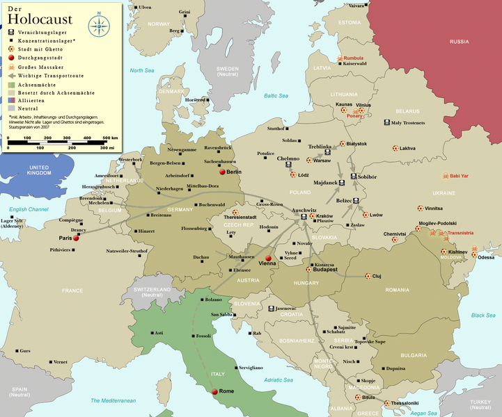
English: Map (with German legend) of the Holocaust in Europe during World War II, 1939-1945. This map shows all German Nazi extermination camps (or death camps), most major concentration camps, labor camps, prison camps, ghettos, major deportation routes and major massacre sites. Please note that a version with 1942 borders is available here: Image:WW2-Holocaust-Europe.png. Notes: 1. Extermination camps were dedicated death camps, but all camps and ghettos took a toll of many, many lives. 2. Concentration camps include labor camps, prison camps & transit camps. 3. Not all camps & ghettos are shown. 4. Borders are present borders (2007). |
| Datum | (UTC) |
| Izvor | |
| Autor |
|
| Ostale verzije |
[]
|


.png)


.png)


| This is a retouched picture, which means that it has been digitally altered from its original version. Modifications: legend and title now german. The original can be viewed here: WW2-Holocaust-Europe-2007Borders.png:
|
Ja, vlasnik autorskog prava ovog djela, ovdje ga objavljujem pod sljedećom licencom:
Ova datoteka je licencirana pod Creative Commons Attribution 3.0 neportiranom licencom.
- Slobodni ste:
- da dijelite – da kopirate, distributirate i prenosite djelo
- da remiksate – da prilagodite djelo
- Pod sljedećim uslovima:
- pripisivanje – Morate pripisati odgovarajuće autorske zasluge, osigurati link ka licenci i naznačiti jesu li napravljene izmjene. To možete uraditi na bilo koji razumni način, ali ne tako da se sugerira da davalac licence odobrava Vas ili Vašu upotrebu njegovog djela.

|
This historical map image could be re-created using vector graphics as an SVG file. This has several advantages; see Commons:Media for cleanup for more information. If an SVG form of this image is available, please upload it and afterwards replace this template with
{{vector version available|new image name}}.
It is recommended to name the SVG file “WW2-Holocaust-Europe-2007Borders DE.svg”—then the template Vector version available (or Vva) does not need the new image name parameter. |
Originalni zapisnik postavljanja
This image is a derivative work of the following images:
- File:WW2-Holocaust-Europe-2007Borders.png licensed with Cc-by-3.0
- 2007-12-17T10:40:36Z Dna-webmaster 1310x1090 (785571 Bytes) == Summary == {{Information |Description=Map of the Holocaust in Europe during World War II, 1939-1945. This map shows all extermination camps (or ''death camps''), most major concentration camps, labor camps, prison camps,
Uploaded with derivativeFX
Historija datoteke
Kliknite na datum/vrijeme da vidite verziju datoteke iz tog vremena.
| Datum/vrijeme | Smanjeni pregled | Dimenzije | Korisnik | Komentar | |
|---|---|---|---|---|---|
| trenutno | 21:01, 2 novembar 2009 | | 1.310 × 1.090 (572 KB) | Flying Saucer | Vaivara correction |
| 22:59, 21 juli 2009 |  | 1.310 × 1.090 (760 KB) | Emdee | legende: Allierte (typo!) -> Alliierten (plural) Große Transportroute -> Wichtige Transportroute | |
| 18:07, 21 juli 2009 |  | 1.310 × 1.090 (760 KB) | Emdee | {{Information |Description={{en|Map (with german legend) of the Holocaust in Europe during World War II, 1939-1945. <br /> This map shows all extermination camps (or ''death camps''), most major concentration camps, labor camps, prison camps, ghettos, maj |
Upotreba datoteke
Nema stranica koje koriste ovu datoteku.
Globalna upotreba datoteke
Sljedeći wikiji koriste ovu datoteku:
- Upotreba na ar.wikipedia.org
- Upotreba na be-tarask.wikipedia.org
- Upotreba na de.wikipedia.org
- Upotreba na en.wikipedia.org
- Upotreba na et.wikipedia.org
- Upotreba na he.wikipedia.org
- Upotreba na pl.wikipedia.org
- Upotreba na ru.wikipedia.org
- Upotreba na zh.wikipedia.org