
Datoteka:Ottoman Provinces Of Present day Libya.png
Veća rezolucija nije dostupna.
Ottoman_Provinces_Of_Present_day_Libya.png (282 × 314 piksela, veličina datoteke: 22 KB, MIME tip: image/png)
| Ova datoteka je s Wikimedia Commonsa. Opis s njene stranice opisa datoteke prikazan je ispod. Commons je skladište slobodnih medija i datoteka za sve projekte fondacije Wikimedia. Možete i Vi pomoći. |

|
This locator map image could be re-created using vector graphics as an SVG file. This has several advantages; see Commons:Media for cleanup for more information. If an SVG form of this image is available, please upload it and afterwards replace this template with
{{vector version available|new image name}}.
It is recommended to name the SVG file “Ottoman Provinces Of Present day Libya.svg”—then the template Vector version available (or Vva) does not need the new image name parameter. |
Sažetak
| Opis |
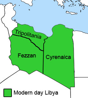
English: The Ottoman Turks conquered the country in the mid-16th century, and the three States or "Wilayat" of Tripolitania, Cyrenaica and Fezzan (which make up Libya) remained part of their empire with the exception of the virtual autonomy of the Karamanlis. The Karamanlis ruled from 1711 until 1835 mainly in Tripolitania, but had influence in Cyrenaica and Fezzan as well by the mid 18th century. |
||
| Datum | |||
| Izvor | self-made but based on this image on this image and this image | ||
| Autor | Esemono; improved by Kirk (talk) | ||
| Dopuštenje (Naknadno korištenje ove datoteke) |
|
||
| Ostale verzije |
Derivative works of this file:
   |
Historija datoteke
Kliknite na datum/vrijeme da vidite verziju datoteke iz tog vremena.
| Datum/vrijeme | Smanjeni pregled | Dimenzije | Korisnik | Komentar | |
|---|---|---|---|---|---|
| trenutno | 14:53, 24 august 2011 | | 282 × 314 (22 KB) | Kirk979 | See discussion |
| 22:46, 11 april 2011 |  | 300 × 350 (35 KB) | ANGELUS | border | |
| 22:35, 11 april 2011 |  | 300 × 350 (39 KB) | ANGELUS | improved | |
| 19:35, 12 oktobar 2009 |  | 282 × 314 (22 KB) | Kirk979 | corrections | |
| 13:00, 1 mart 2009 |  | 282 × 314 (29 KB) | Kirk979 | corrections | |
| 15:43, 17 april 2008 |  | 282 × 314 (25 KB) | Esemono | Category:Maps of Libya Category:Map images that should use vector graphics |
Upotreba datoteke
Sljedeće 2 stranice koriste ovu datoteku:
Globalna upotreba datoteke
Sljedeći wikiji koriste ovu datoteku:
- Upotreba na ar.wikipedia.org
- Upotreba na azb.wikipedia.org
- Upotreba na az.wikipedia.org
- Upotreba na be.wikipedia.org
- Upotreba na bg.wikipedia.org
- Upotreba na ca.wikipedia.org
- Upotreba na cs.wikipedia.org
- Upotreba na da.wikipedia.org
- Upotreba na el.wikipedia.org
- Upotreba na en.wikipedia.org
- Cyrenaica
- Districts of Libya
- Fezzan
- Tripolitania
- Governorates of Libya
- Subdivisions of Libya
- Provinces of Libya
- Postage stamps and postal history of Tripolitania
- Kingdom of Libya
- Postage stamps and postal history of Cyrenaica
- Postage stamps and postal history of Libya
- Postage stamps and postal history of Fezzan and Ghadames
- Template:Regions of Libya
- Category:Regions of Libya
- Revenue stamps of Libya
- Tripolitania (province of Libya)
- Cyrenaica province
- Fezzan province
- Upotreba na eo.wikipedia.org
Pogledajte globalne upotrebe ove datoteke.